Warmer, drier and sunnier than average - the month ending under a heat wave
What an eventful month!
The warmest June (of 10) now recorded at this site - thunder, downpours, a named storm bringing gales and then a heat wave that saw no rain fall in the last ten days of the month during which time we had some beautiful sunny and very warm days.
The thunder and majority of the month's rain came in the first half of the month and quite remarkably for June, there was a named storm 'Hector' on the 14th. Whilst rainfall with Hector wasn't an issue, the wind was with a gale being recorded just before 8 a.m. and with winds gusting to 60 mph several tress were brought down.
The month then settled and would end with a heat wave. The warmest June day was recorded and five successive days from the 25th attained 25°c - it was baking hot, sunny and with barely a cloud in the sky. Whilst the mean minimum temperature was exactly average, the mean maximum was well above and the first time in June to have exceeded 20°c at this site (and which is widely uncommon in Cumbria) and only the third time along with two other occasions, both recorded in July.
By the month's end and following the baking hot conditions one term was starting to become overused ... "It's too hot."
The month saw: 4 days with thunder, one day with hail (10th) and the gale on the 14th.
MSLP of 1020.0 Mb was +4.6 Mb above the local average for June and the highest yet recorded in June for this site. Pressure was relatively high up to the 13th, then unseasonably low for the 14th, before a gradual recovery to become consistently high from the 21st.
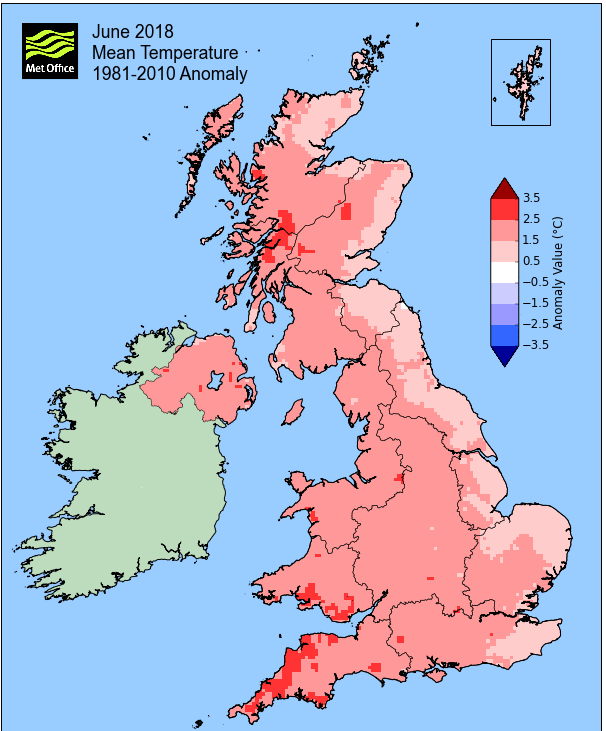
Overall a mean minimum of 8.73°c and a mean maximum of 20.19°c saw the temperature 1.5°c above the 1981-2010 average. It was the warmest June (of ten) yet recorded at this site. The highest maximum temperature recorded was 29.2°c (28th), the lowest minimum 3.2°c (6th).
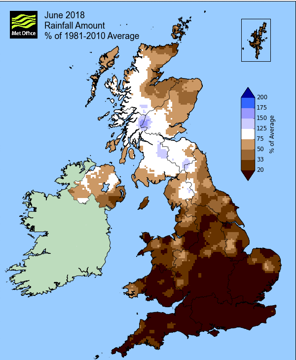
Rainfall of 70.7 mm (Crosby Ravensworth School 92.3 mm - Castlehowe Scar 70.7 mm - Reagill ??? mm) was 85.5% of average for 2007-17 and made it the driest June since 2015. Of the twelve now recorded, six have been drier and five have been wetter.
At the Met' Office site at Newton Rigg, rainfall of 49.4 mm (84.3%) made it the driest June since 2015 and in a series back to 1900, June has been drier in 53 years and wetter in 65 years.
A mean temperature of 14.65°c is the warmest since 1992 and in a series back to 1952, June 2018 is the 5th warmest (in the broken record back to 1914 {4 yrs of missing data} it would be the 6th warmest).
Locally, rainfall percentages were, on the whole, well below average, but with a wide variation. Haresceugh Castle may have only seen 33.3% of average, but the general theme was in the range of 75-90%, but Kirkby Thore with 109% was the one site that was actually wetter than average.
Figures from the Environment Agency’s rainfall sites were, (figure in brackets being the monthly average for 1961-90) ‘Data kindly provided by the Hydrometry and Telemetry team of the Environment Agency (Penrith)’:
Kirkby Thore 46.0 mm (42.2 mm)
Haresceugh Castle (Kirkoswald) 23.09 mm (69.3 mm)
Brothers Water 121.05 mm (131 mm) and
Orton (Shallowford) 68.0 mm (86.6 mm [average for 1967-2017])
151.2 mm at Seathwaite Farm (Borrowdale - 177 mm [average for 1981-2010]).
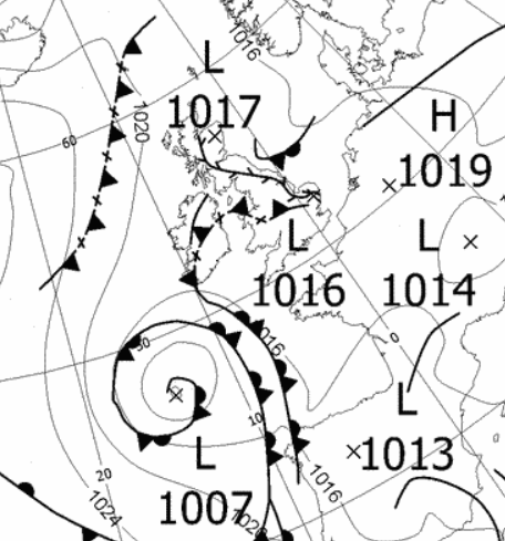
1st - 4th The UK sat within a slack pressure gradient at the start of the month, although with various trough lines circulating over and around the UK, of which, one in particular brought a very heavy period of rain.
The warm conditions from May lingered into June bringing a day of sunny spells on the 1st, although quite muggy. There was a brief spell of thunder with accompanying shower at 1300 hrs, followed by further showers in the afternoon.
Low pressure (LP) in Biscay slowly moved north during the 2nd, which started hazy, becoming overcast in the afternoon. This was all ahead of a significant period of rain that would arrive in the evening. A complicated picture of trough lines and an upper cold front brought the unstable conditions and in a short time with rain of the 'straight down' variety that was literally bouncing off the road, a total of 31.4 mm had quickly fallen.
The 3rd saw a return to a slack pressure gradient before another trough line brought a period of thunder in the early hours of the 4th and whilst the day would stay dry it was mainly cloudy.
5th - 13th High pressure (HP) to the north of the UK would attempt to take control and apart from the 9-10th when there was more thunder, it would remain dry and relatively warm with decent amounts of sun.
From the 5th the temperature tended to range from 20-22°c, the 6th just dipping that bit lower and it remained dry until the 9th when a weak trough line brought a little thunder in the afternoon with a slight shower.
The 10th with an easterly flow and the temperature rising to 22.8°c (73°f) felt more humid and this brought a little thunder in the afternoon, however, the main activity came in the evening. This saw a more prolonged period of thunder with some quite vivid cloud to ground lightning; the accompanying 'storm' saw hail precede the rain with a total of 17.7 mm falling.
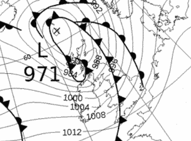
HP from the Atlantic tried to ridge in over the next few days and whilst a little fresher, the days were at least dry. The HP would get shunted east by an area of LP that was travelling quickly across the Atlantic that arrived late on the 13th with some rather interesting conditions.
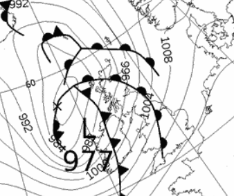
14th 'Storm Hector' arrived overnight into the 14th and which brought a short blast of very unseasonal weather.
'Hector' was indeed an unusually deep and vigorous area of LP for so late in the season; dropping to a central pressure of 969 MB once it exited north of the UK (971 MB whilst passing the UK). It was most notable for its wind strength as opposed to its rainfall and with trees fully laden, many could not cope.
The wind was at its strongest in the ten minutes leading up to 0800 hrs, gusting to 60 Mph and now for the first time in June at this site, gale force. That ten minute period saw a sustained mean speed of 39 mph, gale force, during which time several trees came down. This saw disruption to travel, more notably on the West Coast Main line with trees falling onto the tracks and bringing down the overhead power lines and more locally several fallen trees caused some to be late to school, either taking a long detour or navigating a new assault course!
The rainfall ahead of the storm only totalled 9.0 mm and the rest of the 14th was a gradually improving picture as the LP quickly continued north.
'Storm Hector' an unseasonable low pressure system.
15th - 20th With a series of LP systems arriving from off the Atlantic, it remained fresh and breezy with lower temperatures.
However, rainfall totals were only slight, but the days were often cloudy with only the occasional brighter moments. Temperatures were typically in the range of 15-16°c, but 13.6°c (56.5°f) on the 15th felt chilly.
21st - 30th The warmest period of the month as HP in the Atlantic built and became established over the UK, bringing heat wave conditions from the 25th.
However, at first, with the HP still in the mid-Atlantic and the UK on its eastern edge, there was a N'ly flow down that eastern flank and this kept a lid on the temperatures, typically 16-17°c. Overnight into the 22nd, under clear skies, the temperature fell away to just 3.7°c, but then the day began with gloriously big, blue skies and became a perfect example of how good a day can be even if it remains below 20°c - with 15.6 hrs of direct sun, Shap was the sunniest location in Northwest region of the UK.
The sun was here and now here to stay, just not on the 23rd! A blanket of high cloud and the nagging N'ly saw the temperature struggle to just 16.2°c - but after the 23rd!
Then as the HP migrated east we lost the cooler N'ly flow and as a consequence the temperature began to rise, rapidly. The days were long, sunny and hot!
Whilst the 24th 'only' saw 23.4°c, it wasn't just warming up, it was heating up!
There followed some significantly hot days and from the 25th the next five days all topped 25°c (equalling the record for this site) and included the 3rd, 9th and 10th warmest days recorded at this site.
It started with 25.7°c (25th), then 27.7°c (26th), 28.1°c (27th) and then the month's hottest day, 29.2°c (84.6°f - 28th). The temperature may have peaked, but it remained hot at 26.9°c on the 29th.
These days had little breeze and a baking sun directly above, for many it would be perfect, for others it was just too hot. At least the nights had been just about bearable. Whilst the temperature remained high through to late at night, it did then drop into singles figures on most nights, but with the 26-29th seeing the temperature above 20°c by 1000 hrs there was little reprieve.
Also the 28-29th were quite remarkable for the fact that there wasn't a single cloud in the sky on both days - the sun was relentless. Finally the 30th saw a slight cooling, but only to 24.2°c, albeit a slight breeze made a lot of difference.
It had been a significant warm spell and would continue into July, the 1st would see the temperature back above 25°c - but that's for July's report!
Rainfall totalled 70.7 mm for the month, with rain recorded on 11 days of which 7 were 'Wet days' (1.0mm +).
The Mean Temperature for the month was 14.46°c -- The Mean Max' was 20.19°c -- The Mean Min' 8.73°c.
We had 0 Air Frosts in the month (year 47) -- Grass frosts totalled 0 (year 75).
The 1 foot soil temp ranged from a low of 15.0°c on the 16-17th to a high of 18.6°c on the 29-30th -- with a monthly mean of 16.6°c
The 1 meter soil temp ranged from a low of 12.6°c on the 1st to a high of 14.3°c on the 30th -- with a monthly mean of 13.5°c
COMPARISONS:-
* June 2018 rainfall was 85.5% of the June average for 2008 - 2017
* June 2018 was 1.28°c warmer than the June average for 2009 - 2017 and 1.5°c warmer than the local long term average 1981-2010
* This makes the Jan' to June period of 2018 0.04°c warmer than the average for 2009-17 and with 90.3% of average rainfall for 2007-17
JANUARY 2010
FEBRUARY 2010
MARCH 2010
APRIL 2010
MAY 2010
JUNE 2010
JULY 2010
AUGUST 2010
SEPTEMBER 2010
OCTOBER 2010
NOVEMBER 2010
DECEMBER 2010
JANUARY 2011
FEBRUARY 2011
MARCH 2011
APRIL 2011
MAY 2011
JUNE 2011
JULY 2011
AUGUST 2011
SEPTEMBER 2011
OCTOBER 2011
NOVEMBER 2011
DECEMBER 2011
JANUARY 2012
FEBRUARY 2012
MARCH 2012
APRIL 2012
MAY 2012
JUNE 2012
JULY 2012
AUGUST 2012
SEPTEMBER 2012
OCTOBER 2012
NOVEMBER 2012
DECEMBER 2012
SUMMER 2012
REVIEW OF 2012
JANUARY 2013
FEBRUARY 2013
MARCH 2013
APRIL 2013
MAY 2013
JUNE 2013
JULY 2013
AUGUST 2013
SEPTEMBER 2013
OCTOBER 2013
NOVEMBER 2013
DECEMBER 2013
REVIEW OF 2013
JANUARY 2014
FEBRUARY 2014
MARCH 2014
APRIL 2014
MAY 2014
JUNE 2014
JULY 2014
AUGUST 2014
SEPTEMBER 2014
OCTOBER 2014
NOVEMBER 2014
DECEMBER 2014
WINTER 2014
REVIEW OF 2014
JANUARY 2015
FEBRUARY 2015
MARCH 2015
APRIL 2015
MAY 2015
JUNE 2015
JULY 2015
AUGUST 2015
SEPTEMBER 2015
OCTOBER 2015
NOVEMBER 2015
DECEMBER 2015
REVIEW OF 2015
JANUARY 2016
FEBRUARY 2016
MARCH 2016
APRIL 2016
MAY 2016
JUNE 2016
JULY 2016
AUGUST 2016
SEPTEMBER 2016
OCTOBER 2016
NOVEMBER 2016
DECEMBER 2016
REVIEW OF 2016
JANUARY 2017
FEBRUARY 2017
MARCH 2017
APRIL 2017
MAY 2017
JUNE 2017
JULY 2017
AUGUST 2017
SEPTEMBER 2017
OCTOBER 2017
NOVEMBER 2017
DECEMBER 2017
REVIEW OF 2017
JANUARY 2018
FEBRUARY 2018
MARCH 2018
APRIL 2018
MAY 2018
OTHER ARTICLES
The Oldest Inhabitant
An Inch Of Scotch Mist
But it's meant to be Summer (Summer 2017)
© Darren Rogers 2010-18
Want to comment on this site? email